Monday, October 22, 2012

Bald Mountains, TN/NC

First, allow me to apologize for the delay in this post. I’ve done my best to dutifully stick to my Thursday posts every week, but life is what happens when you’re busy making plans. I suppose it’s naïve to think I can keep up the weekly posts ad infinitum, so don’t be surprised if I miss a week – as I shouldn’t have been.
Sunday before last, I chose to hike a brief portion of the Appalachian Trail on the border of Greene County, TN and Madison County, NC. The Bald Mountains run along the TN/NC border east of Greeneville, TN and I began my hike northeast of Camp Creek Bald, a prominent mountain in the area. The AT faithfully follows the ridgeline, passing by cliffs on either side of the main ridge. The first set of cliffs - Blackstaff Cliffs - are easily seen from the terminus of Viking Mountain Rd.
Blackstaff Cliffs
As I began my hike, I was awkwardly followed by a group of conservative Mennonites from southern Illinois. I prefer to hike alone, that’s why I typically hike more secluded, remote routes. But whenever I come upon other hikers, I let them pass by – but the group of 5 or 6 Mennonites wouldn’t pass. For about a quarter mile, they stayed about 200 feet behind me. I would stop, they would stop. I would start again, and so would they. They matched my pace, no matter how fast or slow. After 20 minutes of awkwardness, I walked up to the group and introduced myself. The oldest male member was the only one to speak, but they all seemed very friendly – we quickly concluded a discussion of the foliage and weather among a fascinating array of topics, and I resumed my hike off-trail until they had passed.
Off-trail, I found myself in a dense patch of shrubbery and laurel. I bushwhacked my way to the bottom of Blackstack Cliffs, but couldn’t find a route to the top that didn’t require climbing. So I backtracked a bit and made my way back to the AT. Finding the trail all to myself, it wasn’t much farther to the narrow spur trail which leads to the top of the cliffs.
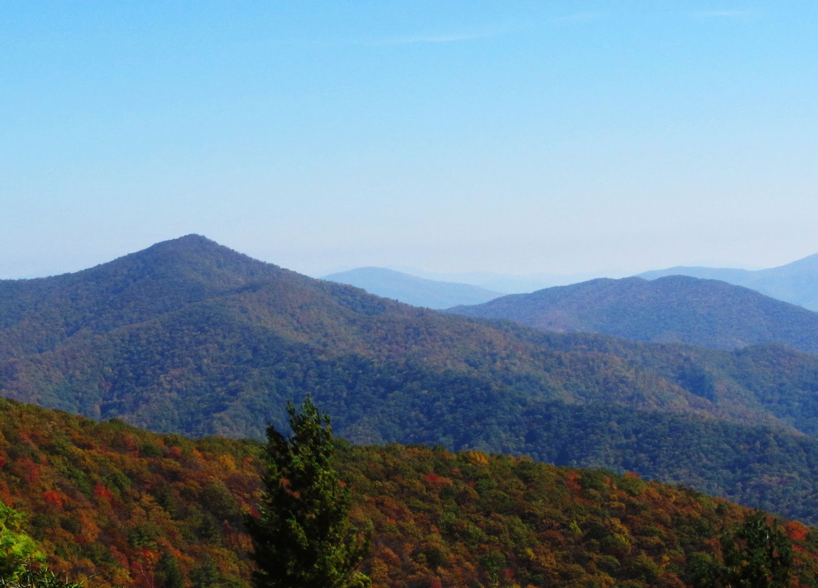
The view west from the top of Blackstaff Cliffs
After returning to the AT, it’s another mile or so of steady hiking until it becomes “Exposed Ridgeline Trail” and traverses Firescald Knob. After winding beneath rock ledges and through dense laurel hells, the trail climbs out of the shaded depths of the ridgeline and emerges onto a rocky trail providing 360-degree views of the region.


The winds were pretty strong...
This is at maximum-zoom for my camera - you can barely make out Mt. LeConte in the Smokies on the horizon.

The views were amazing. The skies were cloudless, with only a slight haze obscuring views at the horizon. The leaves were near peak color and the strong winds along the knife-like ridge dried the sweat on my face. I hiked along Firescald Ridge until it descended into seclusion again, turned around, and traced my steps back along the AT.

I hiked all the way back to the spur trail for Blackstaff Cliffs, and took a similar trail on the opposite side of the AT which descended a ridge into NC. I was looking for the trail to Whiterock Cliffs and made an educated guess that this trail was correct; it was. My “educated” guesses usually end with disappointment and a difficult bushwhack. The trail climbed down precarious outcrops, finally terminating just beyond Whiterock Cliffs. The views were great and it’s always exciting to find a secluded spot on a rock from which you can’t see anything man-made. Miles and miles of wilderness.


Whiterock Cliffs


No matter where I hike in the region, it’s difficult to find a spot where you can’t see a road or a house or a power-line. Most scenic views have been tainted with the proximity of man’s creation, and it’s often my goal to reach places in the southern Appalachians where one can still find the solitude enjoyed by early settlers. Mission accomplished.
Thanks for reading!


Thursday, October 11, 2012

Roan Mountain, TN

The woods can be scary. Particularly at night or during a storm, when one of your senses has been neutralized and you're at an uncomfortable disadvantage - you're comparitively weak, slow, and clumsy to every animal watching you. You can't see or you can't hear. You're defenseless.

More than night or rain or snow, the eeriest condition for hiking is fog. Thick fog. The hike I had planned for last Sunday was ambitious - I intended to hike the ridgeline of the Roan Highlands along the TN/NC border. This stretch of hiking along the Appalachian Trail (AT) meanders through dense spruce forests and wide-open grassy balds which provide fanstastic 360-degree views for miles and miles. It's a great hike.

I was closely watching the weather the days prior to my hike and realized that, given the rain moving into the area, the views wouldn't be as spectacular as normal. But, resolute, I had a plan and stuck to it. As I left the small town of Roan Mountain and climbed higher and higher onto the mounain itself, the fog became denser by every foot of elevation gained. By the time I parked my car at Carvers Gap on the TN/NC-line, visibility was at about 50 feet. That was the best view I had all day.

As I headed northbound on the AT, I climbed the ridge toward Round Bald, and should have seen sweeping views of North Carolina; instead, I saw this:


The fog was so thick that judging distance was almost impossible. My camera was stowed in my pack most of the time because the thick fog and mist driven against me by the powerful winds soaked everything. By the time I reached the top of Round Bald and hiked on toward Jane Bald, photography was impossible.


Round Bald, 5826'

As I walked blindly along the AT, I crossed onto the rugged Jane Bald and from there to Grassy Ridge Bald. All the while, I was treated to the same view, with my visibility limited to 20ft, at best.


 A stunning view into NC.
I completed my hike at Grassy Ridge Bald and made great time on the way back, navigating the trail I couldn't see. As I reached the top of Jane Bald once again, I heard voices below me on the ridge. A woman yelling at a man. As I walked within view, the woman called me over to them. The couple had set out for a morning run at 6:00 and had gotten lost in the dense fog; I came upon them at 12:00. They knew they needed to head southbound on the AT to reach their car at Carvers Gap, but this stretch of the AT, though technically southbound, headed slightly north. They were so confused. It didn't help that the trail they were hiking wasn't the AT, but a spur trail below the ridgeline. I guided them back to the AT, gave them my map, and pointed them in the right direction. The frustrated woman and the embarassed man ran into the fog without so much as a thank you.

I stopped in the forest for a quick break on the way back, snapped a few pictures as the fog lifted from among the trees, and hiked my way back down to my 4Runner. Though the views weren't quite what I had in mind for yet another epic blog post, the hike was refreshing and it was the first time I've been cold in months - it felt great. I can't wait for winter.

Oh, I almost forgot. Obligatory knife picture.


Thanks for reading!


Thursday, October 4, 2012

Little Stony Creek, VA

Last weekend I traveled above Dungannon, VA to explore the Little Stony Creek gorge. Though the name may be underwhelming, the creek is rocky and rugged and is a powerful natural force when flowing at full volume. Popular with whitewater kayakers and hikers alike, Little Stony Creek is best known for its waterfall; at a voluminous 25ft. free-fall, Upper Little Stony Creek Falls is a beautiful point of interest in our region.
I knew this hike wouldn’t be long; two hours, tops. So I took the scenic route to Dungannon, utilizing the miles of highway winding through Jefferson National Forest and the pleasant fall day. I began my hike at the rim of the gorge on a relatively level hike to an outcrop by the name of Bear Rock.
The views from Bear Rock are amazing. The last third of the hike to the outcrop is on exposed rock, with sparse canopy and periodic vistas of the rugged gorge below. The final jaunt onto Bear Rock can be a bit treacherous – the rocks composing the cliff are separated by deep crevices and chasms and can be easily overlooked if your gaze is fixed to the sweeping views. Aside from the graffiti tagged onto the rocks over the years, the area is a great display of the rugged beauty of the southern Appalachians.


The forest service road meanders past the trailhead for Bear Rock and climbs down into the head of the gorge, ending at a parking area for the falls. The hike to the waterfall is short and easy; a convenient bridge crosses the creek directly above the falls and allows the hiker to avoid negotiating the steep cliffs of the gorge or fording the stream. Directly down the trail from the bridge are stone steps which gently drop down into the basin of the waterfall. As expected, the falls are thunderous – with the recent rains, its flow was up, but I imagine the sound made when the creek is flowing at full-force is awesome.


The trail continues past the steps to the falls and follows the creek for its entire length through the gorge. A moderate distance downstream from the main waterfall is an impressive cascade directly below a second bridge crossing. I spend most of my hikes clawing my way through thickets, scrambling up cliffs, and wading through water, slipping on algae – so it was nice to hike on a well-maintained trail with bridges. The area isn’t hard to access; as I left, a couple were having engagement pictures taken at the falls. The future misses had hiked down in high-heels.
This hike wasn't nearly as remote as many hikes I've done, but wild and beautiful nonetheless.  Check it out sometime. Just another treasure hidden away in our part of the world.
Thanks for reading!